Typhoon vs Hurricane vs Cyclone: Same Storm, Different Names?
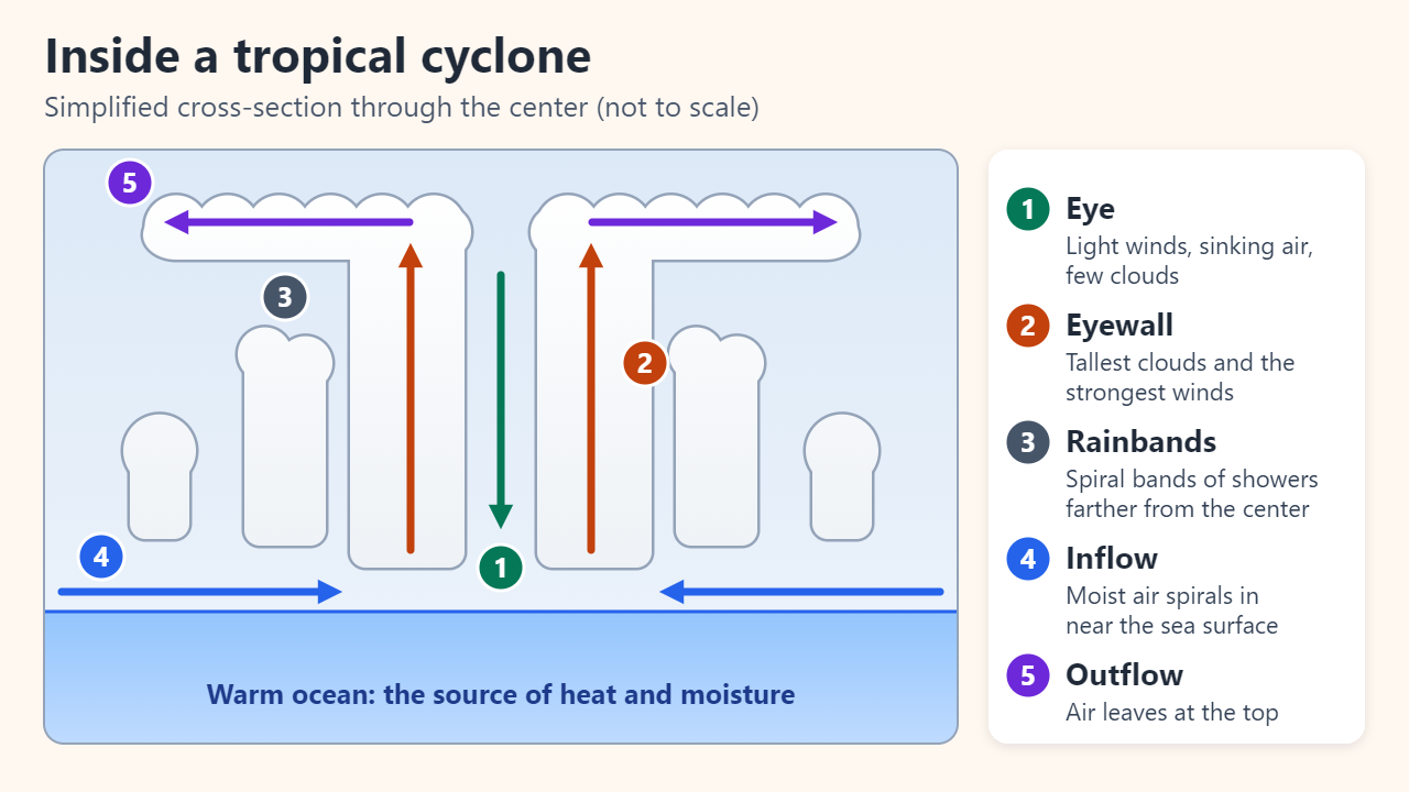
Typhoons, hurricanes and cyclones are the same kind of storm: a tropical cyclone, a rotating low-pressure system powered by warm ocean water. The name simply depends on where the storm forms. It is a hurricane in the North Atlantic and the eastern and central North Pacific, a typhoon in the northwest Pacific, and a cyclone in the Indian Ocean and the South Pacific. What really differs is the bookkeeping: weather agencies average wind over different periods and draw their category lines in different places.
What a tropical cyclone is and how it forms
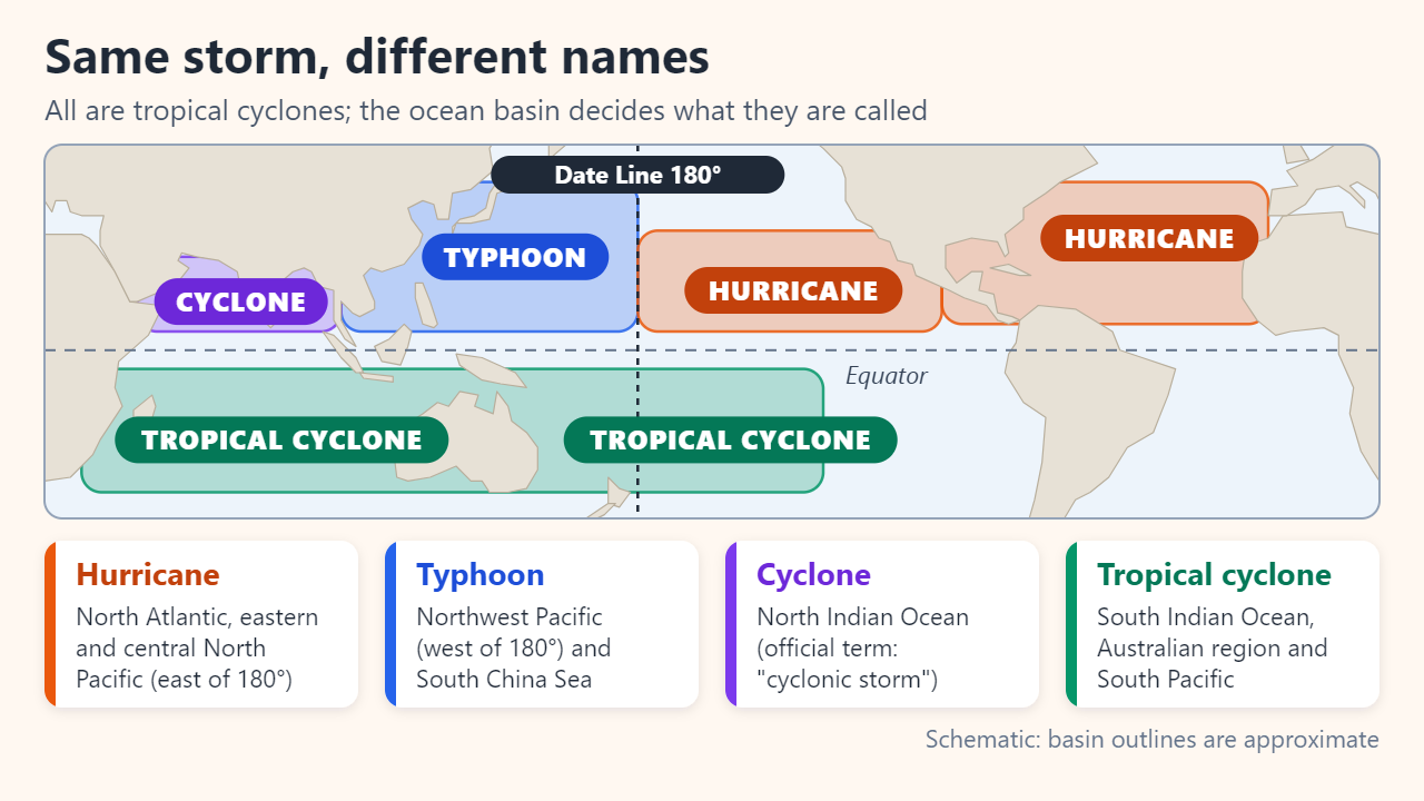
Meteorologists use tropical cyclone as the umbrella term for an organized, rotating system of thunderstorms with a closed low-level circulation that develops over tropical or subtropical water. NOAA lists the conditions that normally have to come together first:
- Ocean water of at least about 26.5–27°C (80°F) through roughly the top 46 m (150 ft).
- An atmosphere that cools quickly with height, so moist air keeps rising.
- Moist air in the middle troposphere, around 4,900 m (16,000 ft).
- A pre-existing disturbance near the surface, such as a cluster of thunderstorms.
- Weak vertical wind shear, roughly under 37 km/h (23 mph) between the surface and the upper troposphere.
- A location generally at least 480 km (300 miles) from the equator, so Earth's rotation can start the spin.
The fuel is latent heat. Water vapor evaporated from the sea releases heat when it condenses into cloud, which warms the air column and draws in more air at the surface. The Japan Meteorological Agency (JMA) notes that friction constantly drains a storm's energy; cut off from warm, moist air, it would die out within two to three days. That is why storms weaken quickly after landfall or over cool water.
Hurricane, typhoon or cyclone: which name applies where
The U.S. National Hurricane Center (NHC) uses hurricane for Northern Hemisphere storms between the Greenwich meridian and the International Date Line, and typhoon for Pacific storms north of the equator and west of the Date Line. Other basins have their own terms and their own averaging rules:
| Ocean basin | Common name | Lead forecast center | Wind averaging |
|---|---|---|---|
| North Atlantic, Caribbean | Hurricane | NHC (Miami) | 1 minute |
| Eastern and central North Pacific | Hurricane | NHC; Central Pacific Hurricane Center (Honolulu) | 1 minute |
| Northwest Pacific, South China Sea | Typhoon | JMA (RSMC Tokyo) | 10 minutes |
| North Indian Ocean | Cyclonic storm ("cyclone") | India Meteorological Department (RSMC New Delhi) | 3 minutes |
| Southwest Indian Ocean | Tropical cyclone | Météo-France (RSMC La Réunion) | 10 minutes |
| Australian region, South Pacific | Tropical cyclone | Australian warning centers; RSMC Nadi (Fiji) | 10 minutes |
Because the labels are geographic, a storm can change its title mid-life. A hurricane that drifts west across the 180° meridian becomes a typhoon, and it keeps the name it already had.
Why the wind thresholds don't match
Two technical choices explain most of the confusion. The first is the averaging period. The NHC's maximum sustained wind is the highest 1-minute average at the standard 10 m height, while most other agencies, including JMA and the Korea Meteorological Administration (KMA), use a 10-minute average, and China's national standard uses a 2-minute average. A shorter average catches more of the gusty peaks, so NOAA's hurricane FAQ puts the peak 1-minute wind roughly 12% above the peak 10-minute wind of the same storm.
The second is where the line is drawn. In Japan and Korea, every tropical cyclone with 10-minute winds of about 17 m/s (34 knots) or more is a typhoon, which includes storms the U.S. would call tropical storms. In its international advisories, JMA splits the same range into tropical storm, severe tropical storm and typhoon, the last starting at 64 knots: the U.S. hurricane number, but on a 10-minute average.
| Agency | Averaging | "Typhoon" or "hurricane" starts at | Top grade |
|---|---|---|---|
| NHC (United States) | 1 min | Hurricane: 64 kt (119 km/h, about 33 m/s) | Category 5: 137 kt (252 km/h) or more |
| JMA (Japan) | 10 min | Typhoon: about 17 m/s (34 kt) | Violent: 54 m/s (105 kt) or more |
| KMA (South Korea) | 10 min | Typhoon: 17 m/s | Super strong: 54 m/s or more |
| CMA (China) | 2 min | Typhoon grade: 32.7 m/s (tropical storm from 17.2 m/s) | Super typhoon: 51.0 m/s or more |
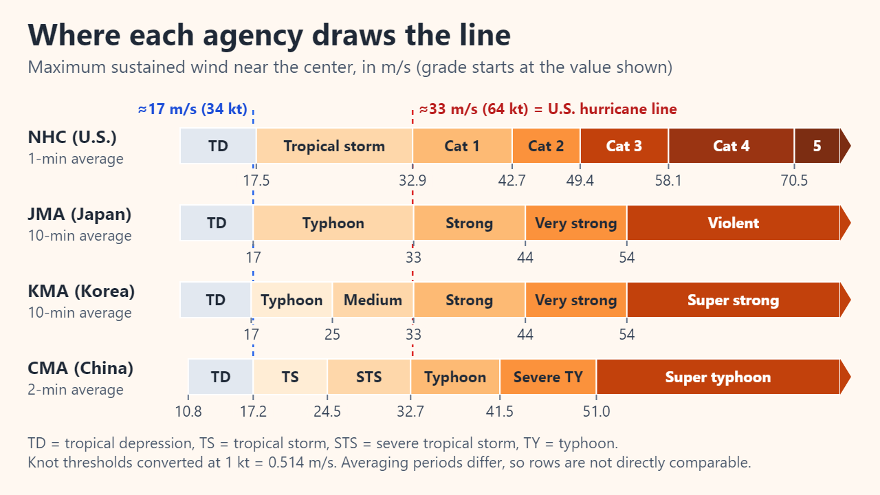
A worked example with illustrative numbers: JMA analyzes a storm at 25 m/s (about 49 knots) on its 10-minute scale. Japanese bulletins call it simply a typhoon, Korean ones a typhoon of "medium" intensity, and JMA's international advisories a severe tropical storm. Placed in the Atlantic, the rough 12% uplift gives about 28 m/s (54 knots) as a 1-minute wind: still a tropical storm, not a hurricane.
Why they spin in opposite directions
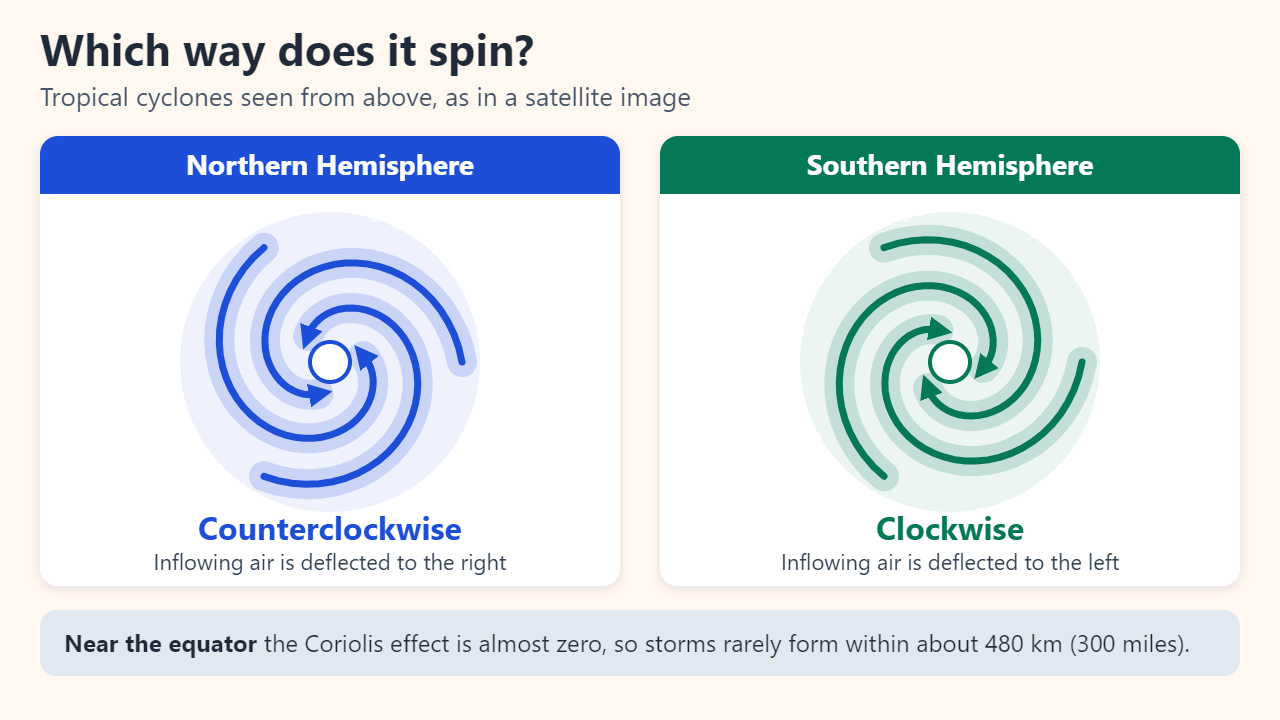
Seen from above, tropical cyclones turn counterclockwise in the Northern Hemisphere and clockwise in the Southern Hemisphere. The cause is the Coriolis effect: air flowing toward the low-pressure center is deflected to the right north of the equator and to the left south of it. Near the top of the storm, the outflow turns the opposite way. The effect is zero at the equator, so storms rarely form close to it; Typhoon Vamei, which formed at 1.5°N near Singapore in December 2001, is a famous exception. The same force is far too weak to decide which way a sink drains.
How tropical cyclones get their names
Short names are faster and less error-prone than coordinates, especially when several storms are active at once. Five WMO regional bodies, from the ESCAP/WMO Typhoon Committee to the RA IV Hurricane Committee, keep lists proposed by member weather services, and storms are not named after particular people. Two well-known systems show the range:
- Atlantic: six alphabetical lists of 21 names, alternating male and female, are used in rotation, so the 2026 list returns in 2032. If a season runs out of names, extra storms take names from an alternate list approved by the WMO; the Greek alphabet, used in 2005 and 2020, has been dropped.
- Northwest Pacific: since 2000, the Typhoon Committee's 14 members have supplied 140 names that are used in sequence regardless of the year. Japan's ten are constellation names. With about 25 typhoons in an average year, the list repeats every five to six years.
- Retirement: when a storm is deadly or costly enough, its name is struck off and replaced in both systems.
Common mix-ups
- "Cyclone" is broader than "tropical cyclone." To meteorologists, any closed circulation turning counterclockwise in the Northern Hemisphere (clockwise in the Southern) is a cyclone, including ordinary mid-latitude lows.
- "Super typhoon" has no single definition. The U.S. uses it for western Pacific storms with 1-minute winds above 150 mph (about 130 kt), Hong Kong for 10-minute winds of 185 km/h or more, and China for 2-minute winds of 51.0 m/s or more.
- A category describes wind only. The Saffir-Simpson scale ignores storm surge, rain flooding and tornadoes, so a Category 1 hurricane can still be deadly.
FAQ
Is a typhoon stronger than a hurricane?
Not by definition, since they are the same storm type. The northwest Pacific sees storms in every month and about 25 typhoons in an average year, and it holds the record for lowest central pressure: 870 hPa in Typhoon Tip (1979). Yet the fastest 1-minute sustained wind on record, 96.2 m/s (185 kt), belongs to Hurricane Patricia (2015) in the northeast Pacific.
Can a hurricane turn into a typhoon?
Yes. A hurricane that crosses the Date Line westward is reclassified as a typhoon, and a typhoon that crosses eastward becomes a hurricane.
Why do Japanese reports say "Typhoon No. 10" instead of a name?
JMA numbers each year's typhoons in order of formation from 1 January. The shared Asian name is used in English and in international bulletins.
Sources: NOAA National Hurricane Center: Glossary of terms; NHC: Saffir-Simpson Hurricane Wind Scale; Japan Meteorological Agency: What is a typhoon? (Japanese); NOAA JetStream: Tropical cyclone introduction.
Related reading
Original illustrations created to help explain this article.